Science & Tech · Science & Environment · 2 hrs ago
El Niño sets Pacific temperature record as event intensifies

El Niño is a natural climate pattern that warms the tropical Pacific and shifts weather around the world.
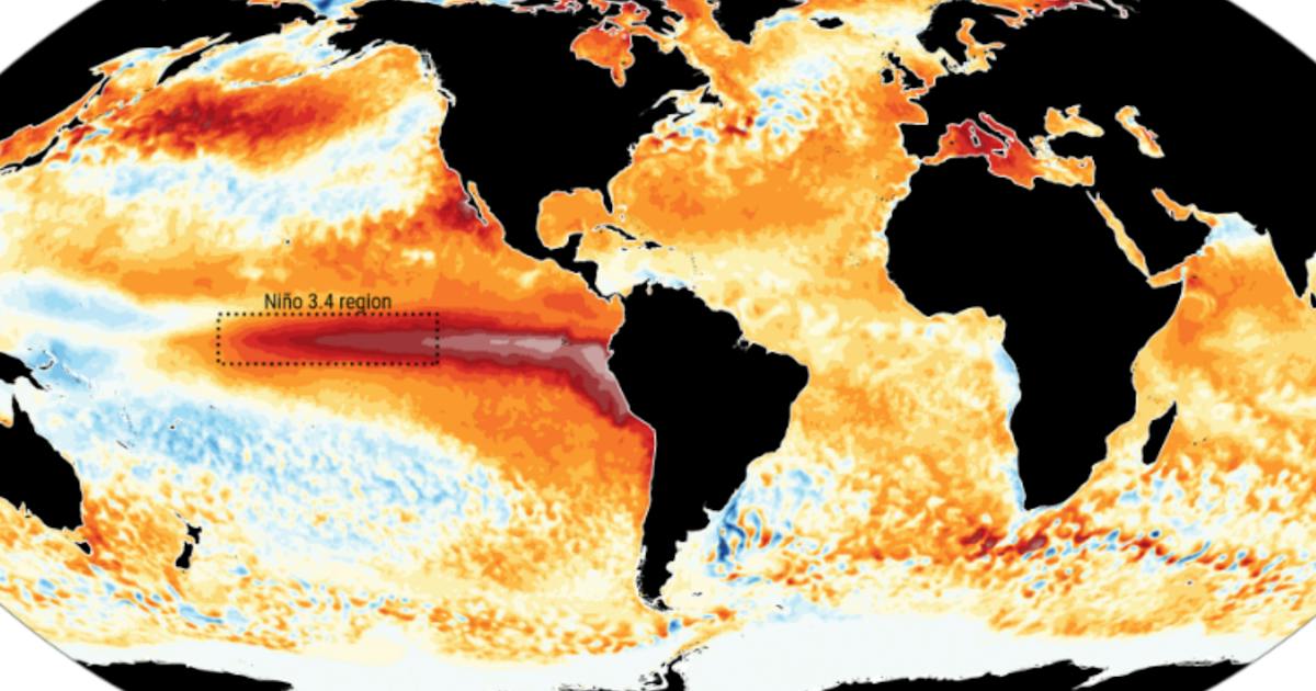
In September, sea temperatures in a key monitoring zone called Niño 3.4 reached 29.70°C, a record according to the EU climate monitor, Copernicus.
The reading was higher than peaks during several previous strong El Niño events.
Copernicus says it cannot yet confirm that the current event is the strongest on record, partly because climate change has raised ocean temperatures and makes comparisons harder.
El Niño can increase the risk of heat, drought and flooding, and can contribute to crop losses.
The event has not yet reached its expected peak later this year, and forecasters say it may push global temperatures to a new record in 2027.
Copernicus also said global average sea surface temperatures set a September record, while the month was the world's second hottest September on record.

The EU’s Copernicus Climate Change Service said Pacific sea surface temperatures in the Niño3.4 monitoring region reached a record 29.70C in September.
The reading exceeded peak temperatures recorded during the strong El Niño events of 1982/1983, 1997/1998 and 2015/2016.
Copernicus said the current event appears exceptionally strong but that it cannot yet say it is the strongest ever recorded.
Japan’s weather agency said El Niño conditions had reached their strongest intensity on record, reflecting differences in how forecasters assess the event.
The intensifying pattern can increase the risk of droughts, floods and extreme heat around the world.
- Who
- The EU’s Copernicus Climate Change Service reported the Pacific temperature record. Japan’s weather agency also assessed the event’s strength.
- What
- Sea surface temperatures in the Niño3.4 region reached 29.70C in September, a record. Copernicus said it could not yet call the event the strongest ever recorded.
- When
- The record was reached in September 2026. Copernicus reported it on October 12, 2026.
- Where
- The Niño3.4 monitoring region of the Pacific Ocean.
- Why
- El Niño is an intensifying natural climate pattern that warms the tropical Pacific and affects weather worldwide.
Copernicus Climate Change Service
Japan’s weather agency
Assessment of strength
Copernicus Climate Change Service
Copernicus said it could not yet say the current El Niño is the strongest ever recorded, noting that a new index accounts for warming tropical oceans.
Japan’s weather agency
Japan’s weather agency said El Niño conditions had reached their strongest intensity on record.
Basis cited
Copernicus Climate Change Service
Copernicus said September’s values pointed to an exceptionally strong event, but the event had not yet peaked.
Japan’s weather agency
The agency said temperatures in the phenomenon’s monitoring area were 4C above normal.
all-time high
cannot yet say that the current El Nino is the strongest ever recorded
We are in a new run of months above 1.5C, and with a strong El Nino still intensifying it is likely to last into 2027
Crossing the Paris Agreement’s long-term limit is only a matter of time. How far we overshoot, and for how long, is still up to us
Sea surface temperatures in the Pacific’s Niño3.4 region reached 29.70C, according to Copernicus.
Japan’s weather agency said El Niño conditions had reached their strongest intensity on record.
Copernicus reported the September temperature record and said it could not yet declare the event the strongest ever recorded.
- Niño3.4 temperature
- 29.70C in September
- Previous strong events compared
- 1982/1983, 1997/1998 and 2015/2016
- Global average sea surface temperature
- 21.05C in September
- Global average surface air temperature
- 16.27C in September
- September temperature above pre-industrial average
- 1.63C
Sources
Related news

Turkish students win record 78 medals at international science olympiads

Used cooking oil may damage modern diesel engines
Heavy rain expected in parts of Turkey as 13 provinces get yellow alerts

Three-volume series on weather support for China’s low-altitude economy published
Hurricane Simon and other weather systems bring heavy rain to Mexico

Heavy rain and flash-flood risk forecast across parts of Saudi Arabia
Hunan launches AI platform for hybrid rice breeding
China’s first five national parks score highly on ecological benefits

CCCC design for deep-sea survey ship passes expert review
September was the world’s second-warmest on record

Brisbane faces a chance of rain and thunderstorms after warmer weather