

7 months ago
Detailed Map Reveals Antarctica's Hidden Terrain
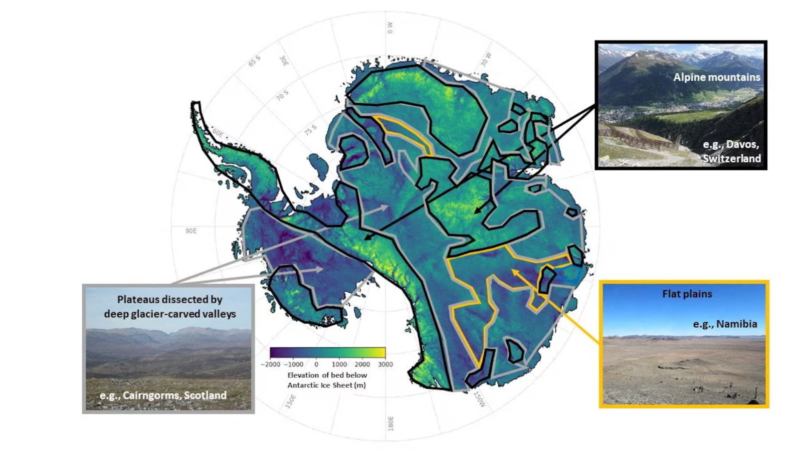
Scientists have made a very detailed map of the land hidden under Antarctica's ice.
They found lots of mountains, valleys, and hills that were not known before.
This map is important because it helps scientists understand how the ice will melt and affect the sea level.
The ice in Antarctica is very thick, and the land under it has different shapes and sizes, just like other continents.
The scientists used special methods and satellites to make this map, which is more complete than any other map before.
They hope this will help make better predictions about climate change and sea-level rise.

Scientists created the most detailed map of Antarctica's subglacial terrain, revealing mountains, canyons, valleys, and plains.
The map identified over 30,000 previously uncharted hills and other smaller features.
The researchers used ice-flow perturbation analysis and high-resolution satellite observations to map the entire continent.
The map is crucial for improving forecasts about the climate-related retreat of Antarctica’s ice sheet and its impact on global sea-level rise.
Antarctica's subglacial features were initially sculpted before the continent was covered in ice over 34 million years ago.
- Who
- Researchers led by glaciologist Robert Bingham of the University of Edinburgh and Helen Ockenden of the Institut des Geosciences de l’Environnement in France
- What
- Created the most detailed map of the subglacial terrain of Antarctica, revealing mountains, canyons, valleys, and plains
- Where
- Antarctica
- When
- The study was published this week in the journal Science
- Why
- To improve forecasts concerning the climate-related retreat of Antarctica’s ice sheet and to better understand the subglacial bedrock landscape
Key facts
- Size of Antarctica
- 40% larger than Europe, 50% larger than the United States, and roughly half the area of Africa
- Ice Sheet Thickness
- Average of 1.3 miles (2.1 km), with a maximum of 3 miles (4.8 km)
- Freshwater Content
- 70% of the planet's freshwater
- Mapping Method
- Ice-flow perturbation analysis and high-resolution satellite observations
- Newly Identified Features
- More than 30,000 previously uncharted hills
- Study Publication
- Journal Science
- Lead Researchers
- Robert Bingham (University of Edinburgh) and Helen Ockenden (Institut des Geosciences de l’Environnement)
Quotes

Robert Bingham
Glaciologist at the University of Edinburgh in Scotland and a lead researcher on the study.
“Possibly the type of landscape that many people might know less is ‘plateaus dissected by deep-carved glacier valleys.’ I can tell you this is very familiar for Scots, but also a landscape that is common across Scandinavia, northern Canada and Greenland. In fact, the very fact that the landscape our technique has uncovered across Antarctica matches these landscapes so well gives us great confidence in our new map.”
 indianexpress.com
“Having the most accurate map of Antarctica’s bed shape is crucial, because the shape of the bed is an important control on friction acting against ice flow, which in turn we need to include in numerical models that are used to project how rapidly Antarctica’s ice will flow towards the ocean, melt and contribute to global sea-level rise.”
indianexpress.com
Helen Ockenden
Glaciologist at the Institut des Geosciences de l’Environnement in France and lead author of the study.
“The method used in the new study is really exciting because it allows us to combine the mathematics of how the ice flows with high-resolution satellite observations of the ice surface, and say what the landscape beneath the ice must look like everywhere across the whole continent, including in all those survey gaps. So we really gain a much more complete idea of how all the landscape features connect together.”
indianexpress.com
“But these surveys often have gaps of 5 km (3.1 miles) or 10 km (6.2 miles) between them, and sometimes up to 150 km (93 miles).”
indianexpress.com
Sources
Related news

Ikea cuts European prices as cost pressures weaken demand

Europe's Bond Selloff Deepens as Middle East Tensions Lift Oil

China’s Rapid Car Development Faces Growing Safety Scrutiny
CNG Prices Rise Rs 2 per Kilogram in Pune

China Challenges US Leadership in Escalating Global AI Contest
