

1 hr ago
El Niño 2026 Heads Toward a Millennium-Scale Record
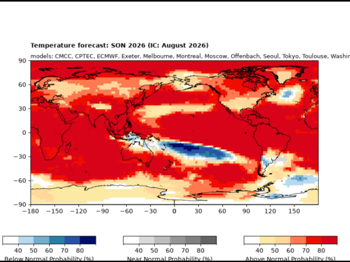
El Niño is a climate pattern that warms a large part of the Pacific Ocean.
In 2026, that ocean area is warmer than scientists have previously recorded for this time.
Its temperature is already slightly above the record set in 2015.
Scientists think it may become even stronger in November or December.
El Niño can change weather around the world.
This year, it has been connected with heatwaves, floods, wildfires and changes to India’s monsoon.
It may also bring heavy snow to six western U.S. states.
The World Meteorological Organization expects it to continue until at least February 2027.

Sea-surface temperatures at the phenomenon’s center reached 3.05°C above the 1991–2020 average, exceeding the 3.02°C record set in November 2015.
Scientists estimate the event could peak at 4.1°C above average in November or December 2026.
The event has been linked to heatwaves, disrupted monsoons, wildfires, floods and extreme temperatures in several regions.
The World Meteorological Organization forecasts nearly a 100% chance that El Niño will persist through February 2027.
El Niño is also associated with a long absence of Atlantic hurricanes and possible heavy snowfall in six western U.S. states.
- Who
- Climate scientists, the World Meteorological Organization, the National Aeronautics and Space Administration, and other forecasting agencies are monitoring the event.
- What
- El Niño in 2026 is intensifying and could become the strongest such event in at least 1,000 years.
- Where
- The phenomenon is centered in the Pacific Ocean and is affecting weather patterns across Europe, the United States, India and other regions.
- When
- The event began in June 2026, could peak in November or December 2026, and is forecast to continue through February 2027.
- Why
- Rising sea-surface temperatures are strengthening the event, which is expected to alter rainfall and temperature patterns and increase risks of extreme heat, floods and droughts.
Key facts
- Current sea-surface temperature
- 3.05°C above the 1991–2020 average
- Previous record
- 3.02°C above average in November 2015
- Possible peak
- 4.1°C above average in November or December 2026
- Forecast duration
- Expected to persist through February 2027
- Global temperature reading
- The first eight months of 2026 were 1.22°C above the average marker
- Potential U.S. snowfall states
- California, Nevada, Utah, Colorado, New Mexico and Arizona
- Atlantic hurricane pattern
- No Atlantic hurricane had occurred by September 15, the longest such stretch since at least 1966
Quotes
Zeke Hausfather
Climate scientist who wrote about the event in a Carbon Brief blog
“El Niño typically peaks in the winter months, most commonly in November or December”
 wionews.com
Sources
Related news
Supersized El Niño Could Become Strongest Ever, UN Warns

WMO Warns Very Strong El Niño Could Reshape Global Weather

US Climate Centre Sees 75% Chance of Historic El Niño
Powerful El Niño May Become Strongest on Record
Earth’s Oceans Reach 125,000-Year Heat Record Amid El Niño
Trump Backs Diesel Export Ban Amid Global Fuel Supply Squeeze

Jio-bp Caps Diesel Sales as Global Supply Pressures Intensify

India Leads Growth Outlook as Global Economy Stabilises, WEF Finds

OnePlus 16 Reveals Lighting Feature, Colors and Teased Specs
