

3 weeks ago
Heavy rain wreaks riverbank erosion across four north Bengal districts
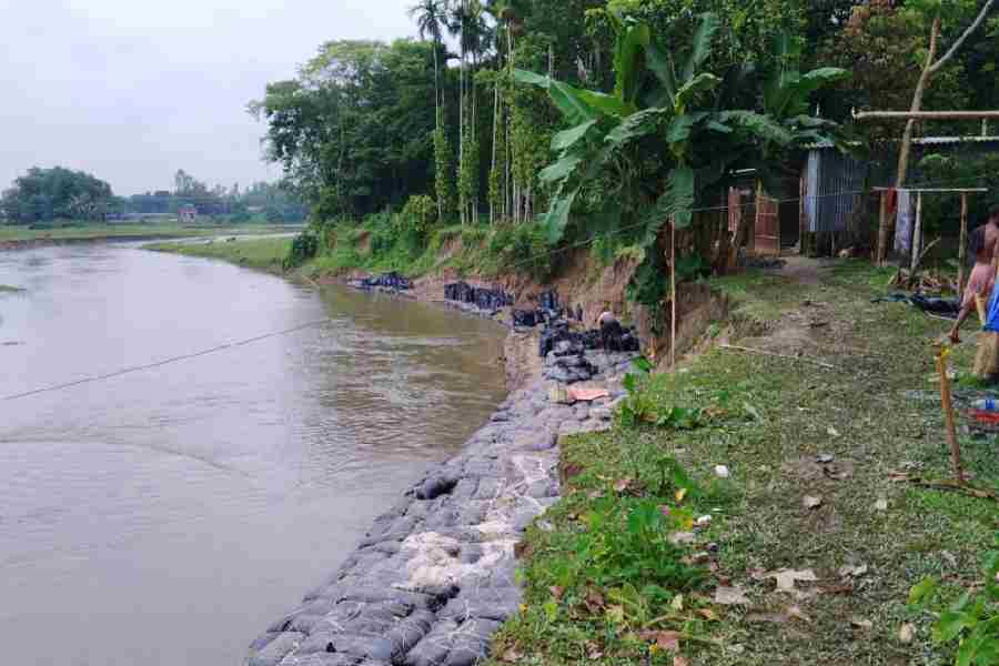
Heavy rain has been falling in a part of India called north Bengal for about a week.
The rain has made the rivers grow big and fast.
When rivers get too full, they push against the land on their sides and wash chunks of it away — this is called riverbank erosion.
The erosion has damaged land in four districts: Siliguri, Jalpaiguri, Alipurduar and Cooch Behar.
Officials found damage in 19 places and think it costs between 10 and 12 crore rupees.
Workers have put sandbags near the rivers to protect the banks and are storing sand, stones and wire mesh for bigger repairs.
The repair work will have to wait until the rain stops and the rivers go down.
Some towns already got more rain this year than they usually get in a whole year.
Because more rain is expected, the flood control room will stay open until October 31.

A week of heavy rain has swollen rivers across north Bengal, eroding riverbanks in Siliguri, Jalpaiguri, Alipurduar and Cooch Behar districts.
The state irrigation department has identified erosion and damage at 19 locations, pegging the loss at ₹10 to ₹12 crore.
Jalpaiguri district recorded the highest number of erosion sites, including along the Diana, Teesta, Jaldhaka and Halimla rivers.
The department has stockpiled sand, stones and wire mesh and placed sandbags at vulnerable spots, but ongoing rainfall has halted field operations.
Rainfall has exceeded normal annual levels in several areas, with Alipurduar at 3,795mm and Banarhat at 3,509mm as of August 5.
- Who
- The state irrigation department (north-east division), led by chief engineer Krishnendu Bhowmik, along with residents of Siliguri, Jalpaiguri, Alipurduar and Cooch Behar districts.
- What
- Prolonged heavy rainfall caused rivers to swell, eroding riverbanks at 19 locations across four north Bengal districts, with damage estimated at ₹10 to ₹12 crore.
- Where
- North Bengal, India — specifically Siliguri, Jalpaiguri, Alipurduar and Cooch Behar districts, including the Siliguri subdivision of Darjeeling district.
- When
- Over the past week, with rainfall data recorded through August 5.
- Why
- Intermittent spells of intense rainfall repeatedly swelled the rivers, leading to erosion across large parts of north Bengal.
Key facts
- Estimated loss
- ₹10 to ₹12 crore
- Districts affected
- Siliguri, Jalpaiguri, Alipurduar, Cooch Behar
- Erosion sites identified
- 19
- District with most erosion sites
- Jalpaiguri
- Rainfall in Alipurduar (till Aug 5)
- 3,795mm
- Rainfall in Banarhat, Jalpaiguri (till Aug 5)
- 3,509mm
- Normal annual rainfall in north Bengal
- 3,400mm–3,500mm
- Flood control room operational until
- October 31
Quotes
Krishnendu Bhowmik, chief engineer of the north‑east division of the state irrigation department
Chief engineer of the state irrigation department
““Jalpaiguri district has recorded the highest number of erosion sites. The rivers which have caused erosion include the Diana near Changmari in Nagrakata, the Teesta near Morichbari in Kranti, the Jaldhaka at Bamandanga‑Tandu and Chintamari, and the Halimla river near Chunabhati‑Palashbari in Banarhat,””
 telegraphindia.com
““Our engineers have conducted field inspections at all vulnerable locations to assess the extent of the damage and prepare erosion‑control plans. Some temporary measures have been taken, and the permanent anti‑erosion work will commence as soon as the river water levels decline.””
telegraphindia.com
Sources
Related news

Ganga Erosion Threatens Villages and School in Bengal’s Malda

Assam vows long-term protection for riverbank communities after erosion

Heavy Rain Floods Kolkata as Bengal Faces More Downpours

Swollen Ganga Sweeps Away Century-Old Bihar Temple
Rathindra Bose Launches Effort to Revive Cooch Behar’s Historic Dighis

Teenage Kabaddi Player Dies After Collapsing During Match

Heavy Rain Warning Issued Across South Bengal This Weekend

Man Arrested in Jangpura Retired Teacher Murder Case
West Bengal Launches Drive for 22 Lakh Migrant Workers
