1 week ago
Book Recasts Bastar’s Abujhmad as the Indigenous Metabhum
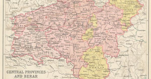
A new book looks at the history of Bastar and a place inside it called Metabhum.
The Hill Maria people who live there have used the name Metabhum for a very long time.
Outsiders later called the area Abujhmad, which means a highland that is difficult to understand.
Early British mapmakers mistakenly treated much of Bastar as an empty or wild place.
Later explorers found a living kingdom with villages, rivers, forests and farms.
British officials then limited access to Metabhum because they wanted to keep the Hill Marias isolated.
These rules continued in modified form after India became independent.
The author says this policy misunderstood the people and their land.
The book argues that Metabhum should be recognized by its local name.

The Hill Marias call the central Bastar highlands Metabhum, while Abujhmad was an outsider-imposed name meaning “highland that cannot be understood.”
Historical explorers and anthropologists documented Bastar’s geography and Hill Maria communities, often using variations of the name Abujhmad.
Metabhum covers about 3,900 square kilometres in central Bastar, with hills, forests, rivers and an average ridge height of 2,500 feet.
British administrators designated the region an anthropological reserve and restricted outside access to preserve Hill Maria isolation.
The book argues that colonial officials misunderstood Bastar as a wild, empty land and urges recognition of the region’s Indigenous name and history.
- Who
- The Hill Maria community, British explorers and administrators, later Indian officials, and author Shantanu Nandan Sharma.
- What
- A historical account argues that Bastar’s central highlands were misunderstood and that the Indigenous name Metabhum should replace the outsider designation Abujhmad.
- Where
- Metabhum, in central Bastar, now an administrative division of Chhattisgarh, India.
- When
- The account spans the late 1700s through the colonial period and post-Independence India, with the author’s field visits occurring in 2017, 2018 and 2023.
- Why
- The author says Abujhmad was imposed from outside and that policies restricting access treated the Hill Marias as isolated anthropological subjects rather than recognizing their society and homeland.
Recognize Metabhum and reduce restrictions
Preserve isolation and existing designation
Place name
Recognize Metabhum and reduce restrictions
The author argues that Metabhum is the Hill Marias’ enduring name and should replace Abujhmad, which was imposed by outsiders.
Preserve isolation and existing designation
Colonial explorers and officials used Abujhmad and related spellings in maps, reports and administrative records.
Access and administration
Recognize Metabhum and reduce restrictions
Critics of isolation argue that treating the Hill Marias as anthropological specimens misunderstood their society and kept the region outside broader development and administration.
Preserve isolation and existing designation
British officials, including DR Rutnam, argued that limiting outside interference would preserve the Hill Marias’ tranquillity and traditional life; similar restrictions continued after Independence.
Understanding Bastar
Recognize Metabhum and reduce restrictions
The book presents Bastar as a functioning kingdom and society that British mapmakers wrongly imagined as empty, harsh or uncivilized.
Preserve isolation and existing designation
Early officials and explorers viewed the difficult terrain, limited access and lack of perceived economic value as reasons to leave parts of Bastar largely unexplored and undisturbed.
Key facts
- Indigenous name
- Metabhum, meaning “highland,” according to the Hill Maria usage described in the article.
- Outsider designation
- Abujhmad, described as meaning “highland that cannot be understood.”
- Metabhum’s area
- Approximately 3,900 square kilometres.
- Bastar’s historical area
- 13,062 square miles, or 33,830 square kilometres, excluding Kanker in the 1872 census.
- Major rivers
- Indravati, Sabari and Taliperu, along with streams including Kotri, Shankhini and Dankini.
- Highest point
- 3,322 feet, located eight miles north-west of the Gudra and Baordig rivers’ confluence.
- Anthropological reserve
- Metabhum was designated an anthropological reserve in the early 1930s, with outside entry restricted by permit.
Sources
Related news
'Rebel Bastar' Book Explores History Behind India's Maoist Insurgency
Mangarh Dham Declined as National Monument
India names 27 Arunachal Pradesh sites to counter China's renaming

India maps 27 Arunachal Pradesh sites to counter China's renaming
Mae Salong Tea Pilgrimage Reconnects Memory, History, and Environmental Costs