7 hrs ago
UN Map's Arunachal Pradesh and Aksai Chin Lines Spark Dispute
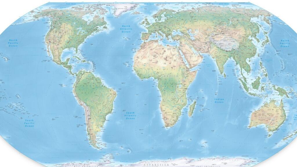
A new United Nations map shows different lines for areas claimed by India and China.
These areas include Arunachal Pradesh and Aksai Chin.
India says both regions should be shown according to its official map.
China controls Aksai Chin, while India claims it as part of Ladakh.
The map labels some borders as Indian lines and others as Chinese lines.
It does not provide an explanation beside these competing lines.
The map also shows a dotted Line of Control between India and Pakistan.
India recently supported a United Nations plan for fairer world maps, but it says that support does not approve every border shown on a map.
This has led to questions about how the United Nations represents disputed territories.

A United Nations map published on July 1, 2026, depicts separate Indian and Chinese claim lines in Arunachal Pradesh and Aksai Chin.
In Arunachal Pradesh, the map labels the southern boundary with Assam a “Chinese Line” and the northern boundary with Tibet an “Indian Line.”
In Aksai Chin, the map marks eastern boundaries as an “Indian Line” and shows a “Chinese Line” separating Ladakh from Aksai Chin.
The map uses a dotted line for the India-Pakistan Line of Control and explains that Jammu and Kashmir’s final status remains unresolved.
India has backed the United Nations’ “Correct the Map” resolution but says support does not mean accepting inaccurate or misleading territorial depictions.
- Who
- India, China, and the United Nations are involved in the dispute over the map’s territorial depictions.
- What
- A United Nations world map has drawn scrutiny for showing separate Indian and Chinese claim lines in Arunachal Pradesh and Aksai Chin.
- Where
- The disputed depictions concern Arunachal Pradesh and Aksai Chin along the India-China boundary, as well as Jammu and Kashmir.
- When
- The map was published on July 1, 2026; the controversy followed India’s support for the “Correct the Map” resolution on September 4.
- Why
- India says Jammu and Kashmir and Ladakh must be shown according to its official map and that inaccurate or misleading representations are unacceptable.
India’s Position
Map’s Depiction
Territorial representation
India’s Position
India says Jammu and Kashmir and Ladakh must be shown according to its official map, and inaccurate or misleading representations are unacceptable.
Map’s Depiction
The map displays separate Indian and Chinese claim lines for Arunachal Pradesh and Aksai Chin.
Competing claims
India’s Position
India claims Arunachal Pradesh and Aksai Chin, with Aksai Chin considered part of Ladakh under India’s position.
Map’s Depiction
The map identifies some boundaries as “Chinese Lines” and others as “Indian Lines,” reflecting competing territorial claims.
Explanation of disputed lines
India’s Position
India’s concerns include the lack of an explanatory note beside the separate claim lines for Arunachal Pradesh and Aksai Chin.
Map’s Depiction
The map includes an explanatory note for the dotted Line of Control in Jammu and Kashmir but no similar note for the Arunachal Pradesh and Aksai Chin claim lines.
Key facts
- Map publication
- July 1, 2026
- United Nations resolution
- India supported the “Correct the Map” resolution on September 4.
- Arunachal Pradesh depiction
- The map labels the boundary with Assam a “Chinese Line” and the boundary with Tibet an “Indian Line”; the boundary with Nagaland is omitted.
- Aksai Chin depiction
- The map marks eastern boundaries as an “Indian Line” and shows a “Chinese Line” separating Ladakh from Aksai Chin.
- Aksai Chin status
- India claims Aksai Chin as part of Ladakh, while the territory is currently under Chinese control.
- Jammu and Kashmir depiction
- A dotted line approximately represents the Line of Control between India and Pakistan, with a note that the territory’s final status remains unresolved.
- India’s position
- India says its support for the mapping initiative does not amount to acceptance of any specific territorial depiction.
Sources
Related news
India Backs UN Map Resolution, Sets Territorial Terms for J&K
India insists UN maps accurately depict J&K, Ladakh
India Seeks Correct Jammu and Kashmir, Ladakh Map Depiction
India-Pakistan Map Dispute Revives Tensions Over Jammu and Kashmir
MEA Reiterates Arunachal Pradesh Integral to India Amid China Row
India Backs UN Resolution Promoting More Accurate World Map
ABVP Paints ‘Free PoK’ and ‘Akhand Bharat’ Slogans at Jadavpur
Pakistan Weighs Province-Like Status for PoK and Gilgit-Baltistan
India-China Border Talks Test Prospects for Early Settlement
MEA Rejects China's Meeting Readout