

World · East Asia & Pacific · 2 hrs ago
Typhoon Champi may bring rain and rough seas near South Korea
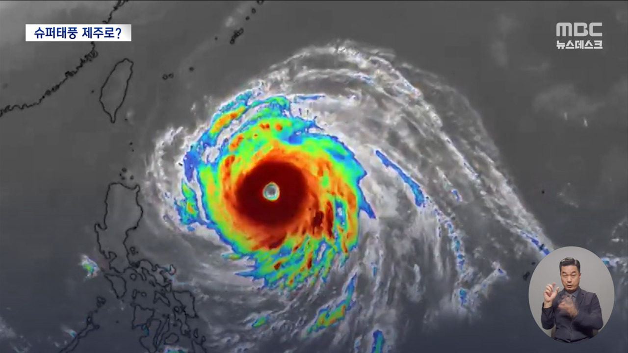
Typhoon Champi has turned northeast after strengthening over waters east of the Philippines and heading toward Taiwan.
It is forecast to pass Taiwan and then travel near waters south of Jeju, South Korea, before moving toward Japan.
The storm is expected to weaken as it moves north and could become an extratropical low near Japan early next week.
Current forecasts say a direct hit on South Korea is unlikely, but the storm’s path could still shift.
Rain bands, strong winds and high waves may affect Jeju and southern parts of the country, with rain also forecast in several regions on October 26.
The storm’s changing path could alter local impacts, so South Korea’s weather agency says people should keep checking forecasts and typhoon updates.
Champi has also prompted weather warnings in Taiwan, where heavy rain and strong winds are expected.

Typhoon Champi is forecast to turn northeast after passing Taiwan and move near waters south of Jeju before heading toward Japan.
A direct landfall in South Korea is considered unlikely, but rain, strong winds and high waves may affect the south and Jeju.
Forecasts differ on how far north the typhoon may travel, with Japan’s forecast bringing it closer to the Korea Strait than South Korea’s and the US forecast.
Champi was reported as an exceptionally powerful storm, with maximum winds around 55 to 56 metres per second in reports dated October 21 and 22.
The storm is expected to weaken as it moves north and may become an extratropical low near Japan on October 26.
- Who
- Typhoon Champi, the 30th typhoon of the year.
- What
- It is forecast to turn northeast after passing Taiwan, potentially bringing rain and rough seas near South Korea.
- When
- The storm is forecast to pass near waters south of Jeju around the weekend and head toward Japan on October 26.
- Where
- Champi is moving from waters east of the Philippines toward Taiwan, then toward waters south of Jeju and Japan.
- Why
- A high-pressure system that had been pushing the storm west is forecast to retreat east, opening a path north.
South Korea and US forecasts
Japan forecast
Expected track
South Korea and US forecasts
South Korea’s and the US’s forecasts take Champi south of Jeju and toward Japan’s Kyushu region.
Japan forecast
Japan’s forecast takes Champi farther north, toward the Korea Strait.
Champi struck Guam, causing widespread power outages and water outages, according to MBC News.
South Korea’s weather agency forecast that Champi would turn northeast after approaching Taiwan and pass near waters south of Jeju.
South Korea’s forecast showed the storm passing through the East China Sea near waters south of Jeju and then turning northeast.
The storm was forecast to head toward Japan and possibly become an extratropical low near the country.
- Storm number
- 30th typhoon of the year
- Maximum winds
- About 55 to 56 metres per second in reports dated October 21 and 22
- Expected South Korea impact
- Rain, strong winds or high waves near the south and Jeju; direct landfall considered unlikely
- South Korea forecast position
- About 30.5° north, 126.9° east at 9 p.m. on October 25
- Possible transition
- Extratropical low near Japan on October 26
3 sources
What people are saying
At this time of year, sea-surface temperatures are low, so the typhoon could weaken quickly, and because the westerlies are strong, typhoons often cannot continue north and instead move east.