

Archive · 23 Sep 2026
Chennai’s Climate Plans Need Communities at the Decision-Making Table
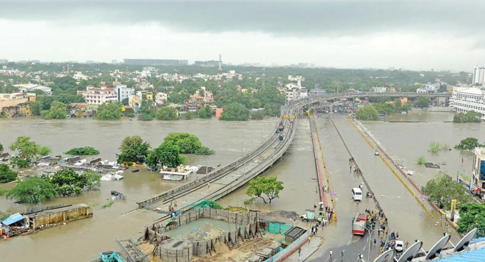
Chennai gets ready for heavy monsoon rain by cleaning drains and preparing pumps.
But experts say the city should also listen to people who live with flooding and heat every day.
Residents may know which roads flood first or which drains overflow.
Scientists can compare these observations with maps, rainfall records and computer models.
This would help officials understand which solutions work and which do not.
Communities could record water depth, flood duration, blocked roads and changes in wetlands.
The information could improve drainage, emergency response and land-use planning.
Experts also say agencies must work together because floods, heat, water shortages and coastal risks are connected.
Community participation should be real and useful, not just a meeting where residents submit complaints.

Chennai routinely prepares for the northeast monsoon by clearing drains, inspecting water bodies and deploying pumps.
Experts say residents’ firsthand knowledge of flooding, heat and water stress should shape climate plans before projects are designed.
Community observations could be tested against rainfall records, satellite imagery, topographical data and hydrological models.
Teachers, frontline workers and resident groups could document local climate impacts through mapping, sensors, photographs and reporting tools.
Participants stress that coordinated, verified community science must address Chennai’s interconnected flood, heat, water, coastal and wetland risks.
- Who
- Chennai residents, environmental groups, scientists, community organizations and government agencies, including experts quoted in the article.
- What
- Experts are calling for communities to help design, document and evaluate Chennai’s climate-preparedness and resilience measures.
- When
- The proposal is particularly timely ahead of and during Chennai’s annual northeast monsoon.
- Where
- Chennai, including flood-prone neighborhoods, wetlands, lakes, canals and the Pallikaranai marshland.
- Why
- Residents hold detailed knowledge of local climate risks, while coordinated community and scientific data could improve planning and address interconnected vulnerabilities.
Community-Led Climate Planning
Structured, Scientifically Verified Participation
Role of local knowledge
Community-Led Climate Planning
Residents should participate as partners before climate interventions are designed, using their firsthand experience to identify risks and failed measures.
Structured, Scientifically Verified Participation
Community input should not replace scientific expertise or be accepted automatically; it should be documented, verified and assessed alongside formal data.
Participation model
Community-Led Climate Planning
Citizen science, community mapping, local reporting and trained volunteers could turn recurring monsoon observations into useful neighborhood-level records.
Structured, Scientifically Verified Participation
Participation must avoid becoming symbolic or overly burdensome, and planning should account for differences related to age, gender and profession.
Government coordination
Community-Led Climate Planning
Connecting communities with scientific institutions and local-government systems could improve drainage, wetland protection, emergency response and land-use decisions.
Structured, Scientifically Verified Participation
Inter-departmental coordination and shared terminology are essential because agencies and experts may otherwise work separately or fail to communicate effectively with communities.
- Climate risks
- Chennai faces intense rainfall, urban heat, water scarcity, coastal risks and degradation of wetlands and water bodies.
- Community knowledge
- Residents can identify flood paths, blocked channels, low-lying areas, heat-exposed locations and failed interventions.
- Potential tools
- Mobile reporting, community mapping, low-cost sensors and citizen-generated photographs could support local monitoring.
- Scientific validation
- Community observations could be compared with rainfall records, topographical data, satellite imagery and hydrological models.
- Possible participants
- Teachers, frontline workers, resident groups and other trusted local actors could document observations.
- Key ecosystem
- The Pallikaranai marshland is described as critical to Chennai’s hydrology and a potential focus for community monitoring.
- Coordination need
- Experts say agencies should coordinate because the watershed operates as one connected system.