

Archive · 6 Aug 2026
Super Typhoon Dolphin may weaken India's monsoon rains
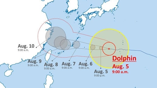
There is a very big storm in the ocean called Super Typhoon Dolphin.
It is spinning very fast with winds stronger than a speeding car.
The storm has already brought lots of rain and big waves to some islands near Japan.
Now it is moving toward China and is expected to arrive around August 8 to 10.
Far away, India gets its rainy season from winds that bring moisture from the sea.
This big storm acts like a giant vacuum cleaner that sucks up moisture from the ocean.
Because of that, India might not get as much rain for a little while.
Some parts of India could have drier weather, especially farms in the middle of the country.
But the storm will get weaker when it reaches land, and then India's rain should come back to normal.

Super Typhoon Dolphin has sustained winds exceeding 175 km/h and gusts up to 210 km/h in the western Pacific.
The typhoon has battered Japan's Daito, Ogasawara, and Ryukyu Islands with heavy rain of 100-350 mm and high sea swells.
Dolphin is projected to pass Taiwan and make landfall on China's eastern coast, likely Zhejiang near Wenzhou or Taizhou, between August 8 and 10.
The typhoon may disrupt India's monsoon by siphoning moisture from the Bay of Bengal and displacing the monsoon trough.
Experts say Dolphin is unlikely to cause a prolonged 'break monsoon' across India, with rain expected to resume after it weakens over China.
- Who
- Super Typhoon Dolphin, a rapidly intensified tropical cyclone
- What
- The typhoon is moving toward China and may weaken India's monsoon rains by altering atmospheric circulation
- When
- Landfall on China's eastern coast is expected between August 8 and August 10
- Where
- Western Pacific Ocean, affecting Japan's outlying islands and heading toward Taiwan and China's Zhejiang province near Wenzhou or Taizhou
- Why
- The typhoon siphons moisture from the Bay of Bengal and displaces the monsoon trough, suppressing low-pressure systems that drive monsoon rains in India
- Maximum sustained winds
- Exceeding 175 km/h
- Maximum gusts
- Up to 210 km/h
- Rainfall on Japanese islands
- 100 mm to 350 mm
- Affected Japanese islands
- Daito, Ogasawara, and Ryukyu
- Projected landfall window
- August 8-10
- Projected landfall area
- China's eastern coast, Zhejiang province near Wenzhou or Taizhou
- Impact on India
- Possible dry spell in interior agricultural belts, short-term heavy rain in coastal western regions like Kerala