

Archive · 2 Sep 2026
Satellite Radar May Strengthen Nepal's Flood Warning Systems
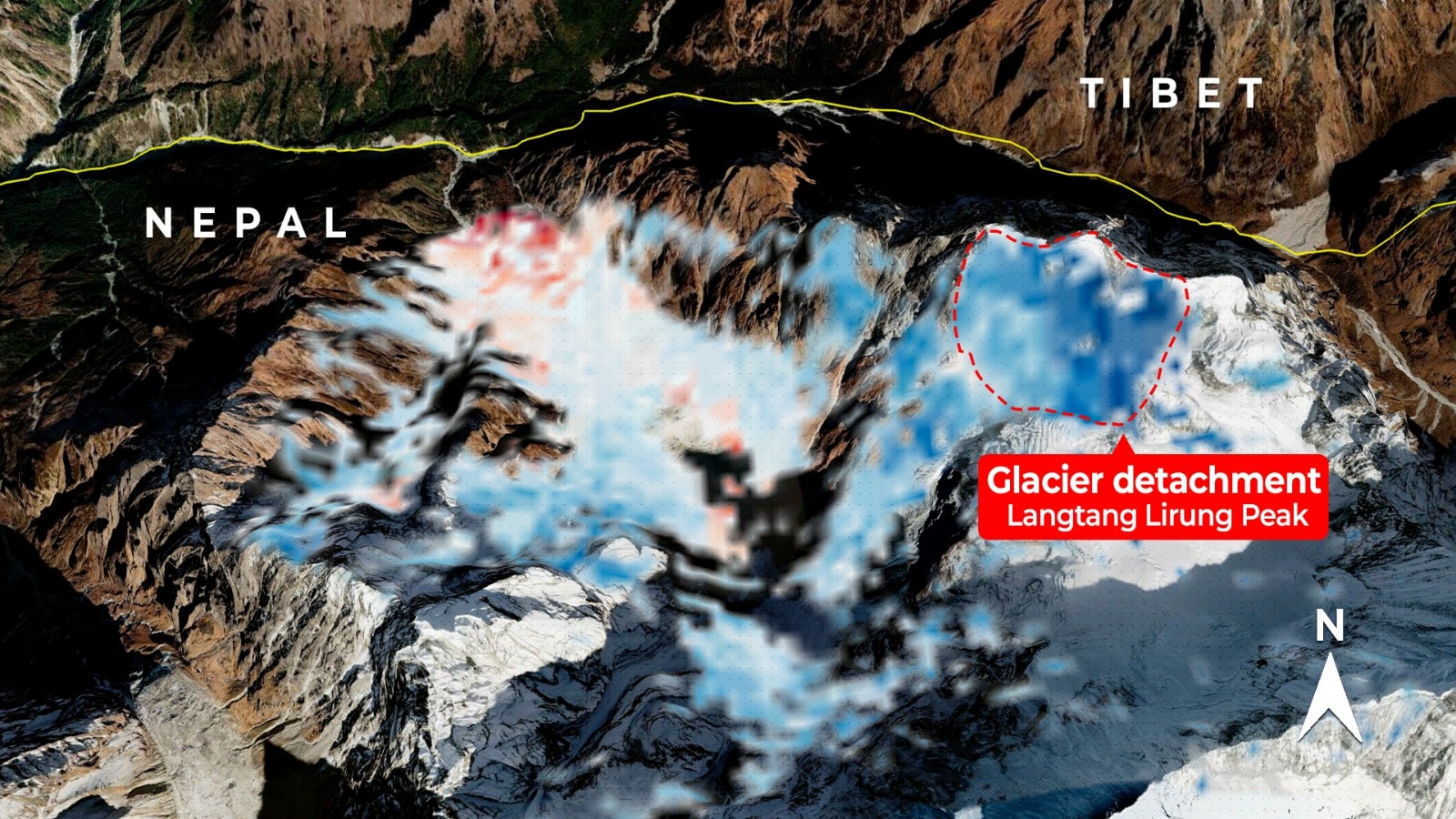
On August 26, a large mass of ice and rock collapsed near Nepal's border with Tibet.
This sent a dangerous wall of mud and water down the Bhote Koshi river.
More than 1,000 people were killed.
Some communities were warned only after the flood had already started.
Scientists studied radar pictures from satellites to look for movement before the collapse.
Radar can work at night and through many clouds.
The pictures suggested that part of the glacier and rock formation had been slowly moving.
However, movement does not always mean a collapse will happen soon.
Experts say satellite data should be combined with measurements from the ground, rivers, weather stations and seismometers.

A glacier-related ice-rock collapse along the Nepal-Tibet border triggered deadly flash floods on August 26.
More than 1,000 people were killed, while some communities received warnings only after flooding had begun.
Sentinel-1 radar analysis indicated that the unstable ice-rock formation had been moving downhill before collapsing.
Other analyses found pre-collapse movement, but estimates ranged from millimetres per month to meter-scale cumulative motion.
Experts say satellites could strengthen warnings when combined with ground, weather, seismic and river-flow data, but cannot predict every collapse.
- Who
- Communities along the Bhote Koshi river, scientists, geospatial experts and researchers in India, China and the United States.
- What
- A glacier-related ice-rock collapse caused flash floods, prompting experts to assess satellite radar for earlier warnings.
- When
- August 26; satellite analyses also examined movement from January through August and during the 2025 snow-melting season.
- Where
- Settlements along the Bhote Koshi river near the Nepal-Tibet border in the Himalayan region.
- Why
- To determine whether pre-collapse ground deformation can be detected early enough to improve downstream flood warnings.
Satellite Monitoring Advocates
Cautious Experts
Value for early warnings
Satellite Monitoring Advocates
Satellite radar, optical imagery, InSAR, LiDAR and related data could help identify deformation, glacier and lake changes, debris movement and downstream exposure.
Cautious Experts
Detecting movement is not the same as predicting when a glacier collapse or landslide will occur, so satellite data alone cannot provide reliable warnings.
Monitoring strategy
Satellite Monitoring Advocates
Continuous satellite observation could help identify instability at vulnerable Himalayan sites before a disaster.
Cautious Experts
Because not every unstable site can be monitored equally, experts recommend prioritizing locations where instability could have severe downstream consequences.
Data requirements
Satellite Monitoring Advocates
Satellite observations could strengthen existing systems when integrated into a broader monitoring network.
Cautious Experts
Reliable warnings require ground measurements, river-flow data, seismic records, high-altitude weather observations and knowledge of how each slope or glacier behaves.
- Disaster date
- August 26
- Reported deaths
- More than 1,000 people
- Trigger
- Collapse of an ice-rock formation along the Nepal-Tibet border
- Primary satellite data
- Sentinel-1 Synthetic Aperture Radar
- Reported movement estimate
- Around 10 millimetres per month since January, according to Manoochehr Shirzaei
- Alternative estimate
- Nearly 51 millimetres per year from April to August, compared with around 18 millimetres per year during the 2025 snow-melting season, according to Spatial Sense
- Key limitation
- Line-of-sight radar measurements may underestimate movement perpendicular to the satellite's viewing direction