Archive · 7 Sep 2026
UN Assembly Backs Equal Earth Map With India’s Support
The United Nations supported using a world map called Equal Earth.
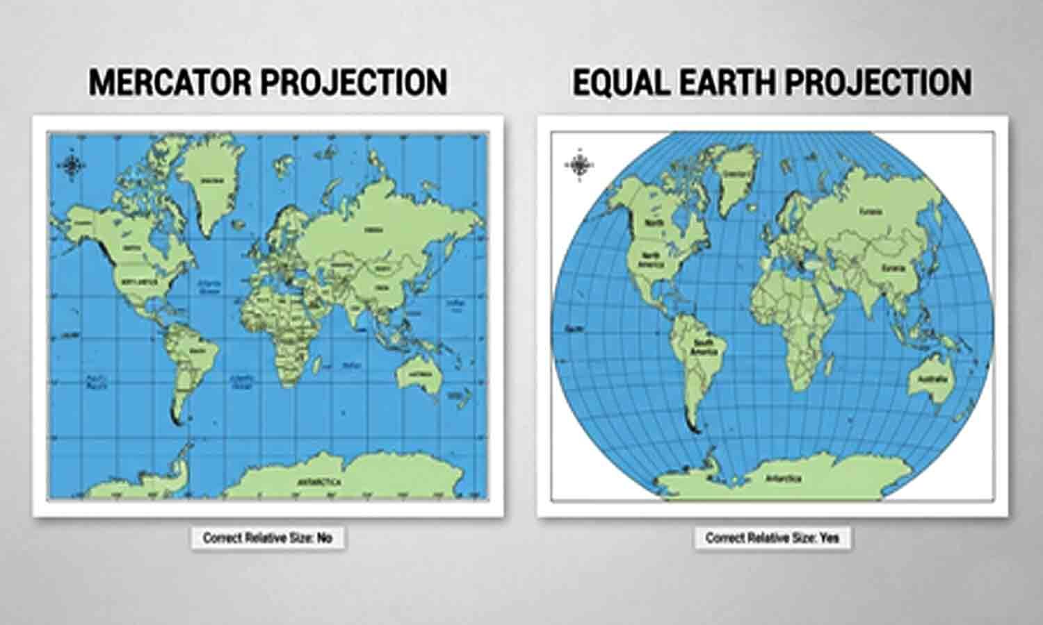
This map shows continents closer to their real sizes.
The older Mercator map makes places near the North and South Poles look much bigger.
For example, Greenland can look about as large as Africa, even though Africa is much larger.
Togo led the campaign for the change, and India voted in favor.
The United States was the only country to vote against it, while six countries abstained.
Supporters said fairer maps could improve how people understand the world.
The resolution is advice, not a rule, so countries do not have to change their maps.
France said it would stop using Mercator maps for some government purposes.

The UN General Assembly backed the Equal Earth Projection in a 164-to-1 vote, with six abstentions.
India supported the advisory resolution, which encourages more accurate depictions of global land areas.
Supporters said Mercator-style maps enlarge northern regions and visually diminish Africa and other Global South areas.
Togo led the campaign, while the United States called the initiative part of a broader ideological project.
The resolution does not require map users to replace Mercator maps, although France said it would stop using them for certain purposes.
- Who
- The United Nations General Assembly, with Togo leading the campaign and India among the supporters.
- What
- The Assembly adopted a non-binding resolution encouraging use of the Equal Earth Projection instead of Mercator-style maps for general representation.
- When
- September 4, described as Friday in the reports.
- Where
- At the United Nations General Assembly.
- Why
- Supporters said Equal Earth represents the relative sizes of continents more accurately and avoids visually diminishing regions of the Global South.
Supporters of the resolution
United States opposition
Purpose of changing maps
Supporters of the resolution
Supporters said Equal Earth offers a more accurate and dignified representation of regions, particularly Africa and the Global South, and can improve geographical literacy.
United States opposition
The United States called the resolution part of a much larger and more radical ideological project and said initiatives like it damage the UN’s credibility.
Meaning of cartographic representation
Supporters of the resolution
Togo’s foreign minister said a fairer map does not change geography but changes how people see the world, potentially encouraging understanding, respect, and peace.
United States opposition
The United States cast the sole dissenting vote, rejecting the initiative despite its non-binding nature.
Practical map use
Supporters of the resolution
The European Union said the resolution is limited to educational, awareness-raising, and geographical-literacy purposes; France said it would abandon Mercator maps for certain uses.
United States opposition
Mercator maps remain widely used, and the resolution does not require countries or institutions to adopt Equal Earth.
- Vote
- The resolution passed with 164 votes in favor, one against, and six abstentions.
- Map supported
- The 2018 Equal Earth Projection, an equal-area map designed to show continents in closer proportion to their actual sizes.
- Map criticized
- The Mercator Projection, developed by Gerardus Mercator for marine navigation and still widely used.
- Campaign leader
- Togo led the campaign, with support from the African Union.
- India’s position
- India supported accurate equal-area representation but said its backing did not require endorsement of one proprietary mapping method.
- Resolution status
- The measure is advisory and does not require governments or institutions to replace Mercator-style maps.
- French response
- France said its foreign ministry would abandon Mercator maps in favor of representations tailored to specific uses.
- Map distortion example
- Mercator maps can show Greenland as roughly the same size as Africa, although Africa has about 14 times more physical area.