Archive · 7 Nov 2025
New Map Shows Roman Empire Had Vastly Larger Road Network
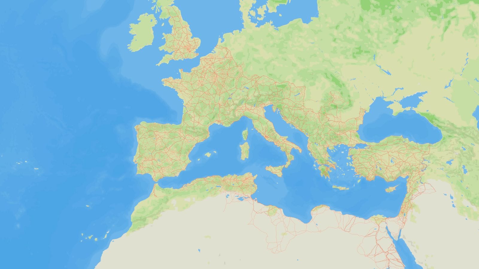
Scientists have created a new map called Itiner-e that shows all the roads the ancient Romans built.
They found out that the Romans built way more roads than we thought – almost 60% more!
This means the Romans had about 300,000 kilometers of roads, which is a lot.
These roads helped people and things travel all over their big empire.
The map was made by looking at old writings, maps, and even pictures from space.
While the map is great for seeing the big picture, some parts are not super precise, and it doesn't include all the tiny local roads.
Also, it helps us understand how long it would take to travel back then, but it might be missing some faster ways people used to travel.

A new map, Itiner-e, details the Roman Empire's land transport network as it existed in AD 150.
The network is approximately 60% larger than previously estimated, totaling around 300,000 kilometers.
The map was created by archaeologists using topographic maps, satellite imagery, and historical documents.
Only 2.7% of the network's length has precisely known locations, with most being less precisely known or hypothesized.
While comprehensive for major routes, the map lacks detail on smaller local networks and has some limitations in travel time calculations.
- Who
- A team of researchers led by Tom Brughmans at Aarhus University
- What
- Created a comprehensive map and digital dataset, Itiner-e, of the Roman Empire's land transport network, revealing it to be significantly larger than previously estimated.
- When
- The map details the road network as it existed in AD 150.
- Where
- Roman Empire
- Why
- To provide a more accurate and extensive understanding of the Roman road system and its infrastructure.
Strengths of Itiner-e
Limitations of Itiner-e
Coverage and Detail
Strengths of Itiner-e
The Itiner-e dataset significantly increases the mapped Roman road network by 59%, covering approximately 300,000 km, with improved coverage in regions like the Iberian Peninsula, Greece, and North Africa.
Limitations of Itiner-e
The map primarily focuses on the 'big picture' and major/secondary roads, with only 2.7% of mapped roads having precisely known locations. Smaller, local road networks, especially around Rome, and much published archaeological evidence remain to be incorporated.
Route Mapping Methodology
Strengths of Itiner-e
Itiner-e adapts routes to fit geographical realities, allowing for practical, winding paths for mountain roads, moving beyond idealized straight lines.
Limitations of Itiner-e
The map incorporates travel times based on walking, ox carts, pack animals, and horse couriers, but omits mule-drawn carriages, which were a major form of passenger travel and preferred for their strength and endurance.
- Map Name
- Itiner-e
- Dataset Researchers
- Team led by Tom Brughmans at Aarhus University
- Estimated Road Network Length
- Approximately 300,000 kilometers
- Previous Mapping Length
- 188,555 kilometers
- Percentage Increase
- 59%
- Year Detailed
- AD 150
- Precisely Known Road Locations
- 2.7%